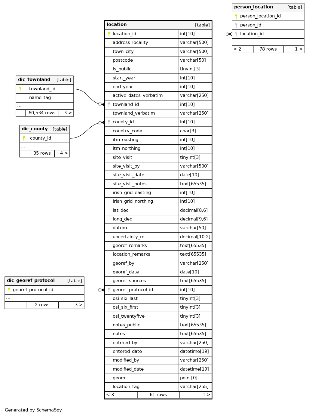
Columns
| Column | Type | Size | Nulls | Auto | Default | Children | Parents | Comments | ||||||
|---|---|---|---|---|---|---|---|---|---|---|---|---|---|---|
| location_id | INT | 10 | √ | null |
|
|
PK autoincrement id |
|||||||
| address_locality | VARCHAR | 500 | √ | NULL |
|
|
Street address where possible, general name/locality if street address is not available |
|||||||
| town_city | VARCHAR | 500 | √ | NULL |
|
|
Town/City/Village name |
|||||||
| postcode | VARCHAR | 50 | √ | NULL |
|
|
Postcode/eircode |
|||||||
| is_public | TINYINT | 3 | √ | 1 |
|
|
Whether the location is public or not (will appear on website) |
|||||||
| start_year | INT | 10 | √ | NULL |
|
|
Year the site opened |
|||||||
| end_year | INT | 10 | √ | NULL |
|
|
Year the site was closed |
|||||||
| active_dates_verbatim | VARCHAR | 250 | √ | NULL |
|
|
Active dates, in whatever format is available. |
|||||||
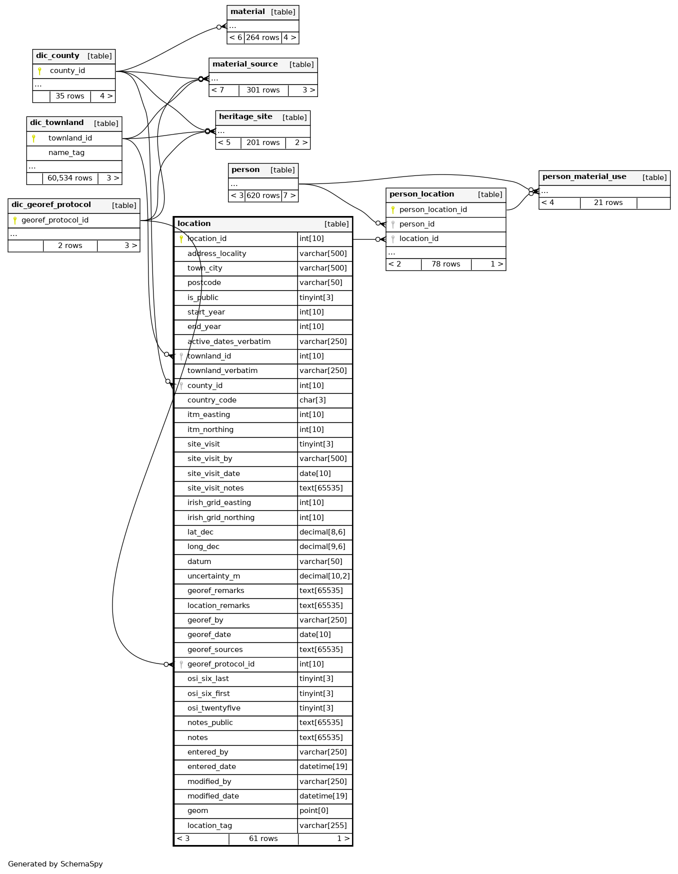
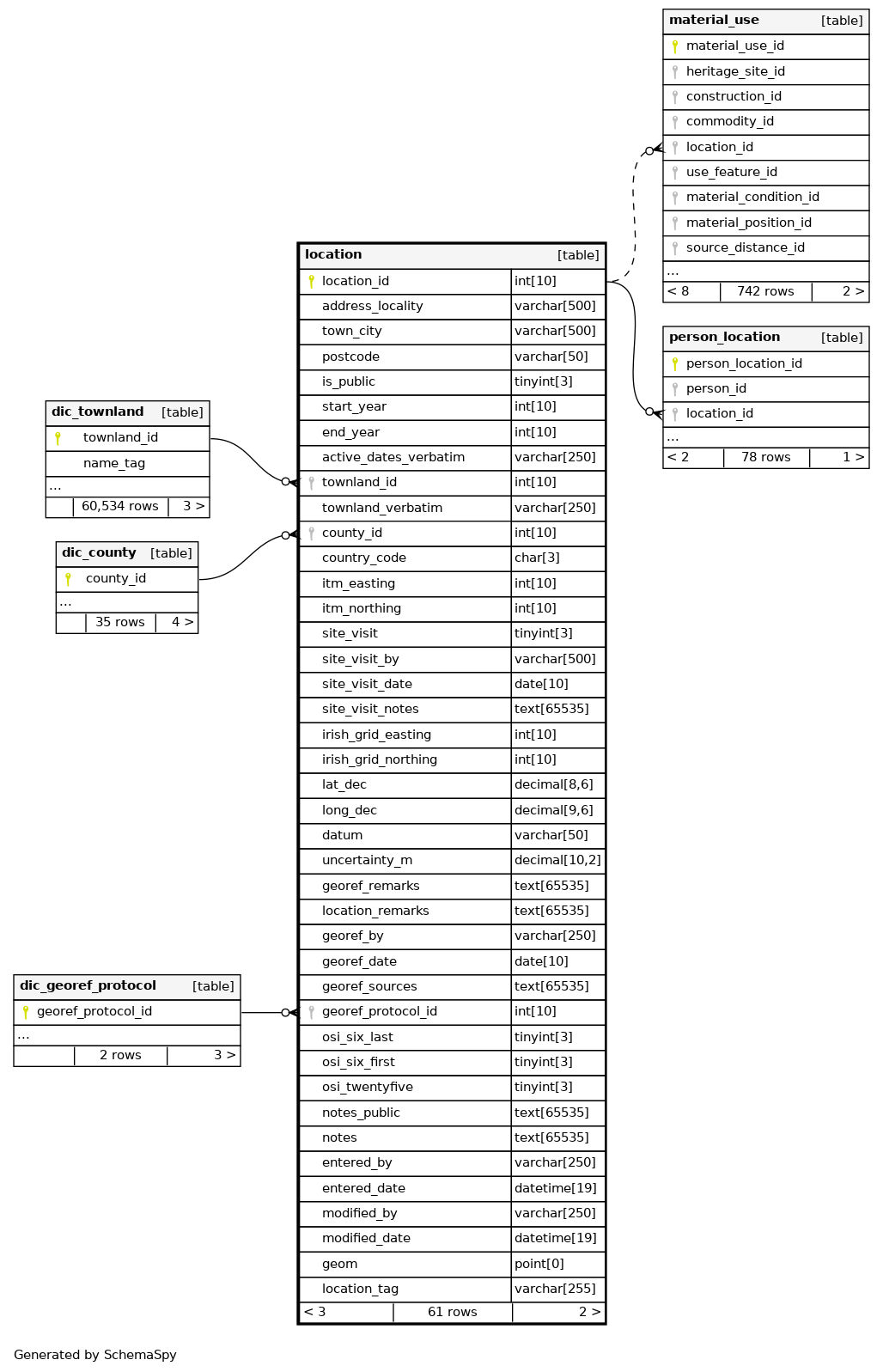
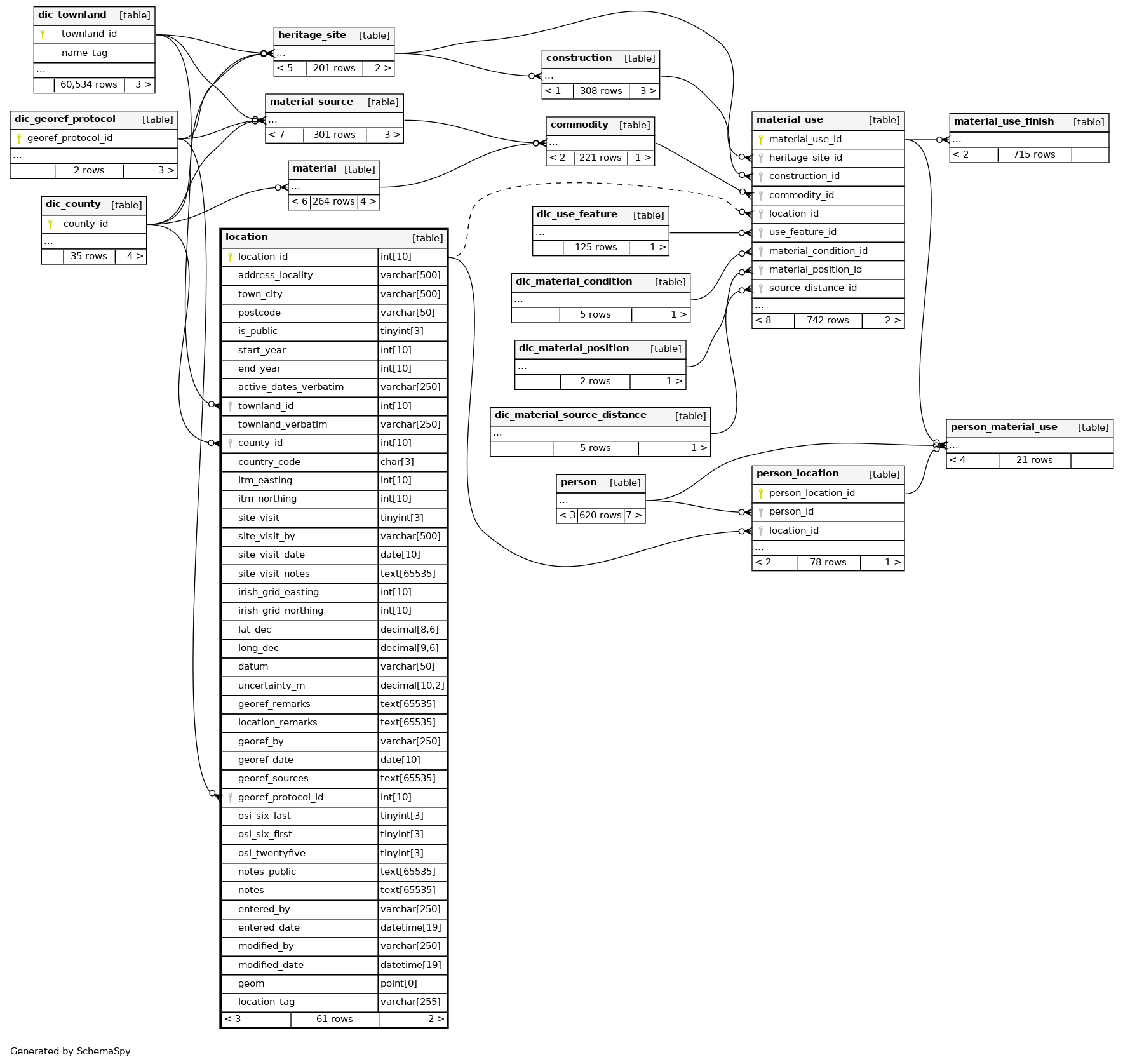
| townland_id | INT | 10 | √ | NULL |
|
|
FK Links to dictionary from townlands.ie |
|||||||
| townland_verbatim | VARCHAR | 250 | √ | NULL |
|
|
Verbatim townland - may include parishes etc where townland is not available |
|||||||
| county_id | INT | 10 | √ | NULL |
|
|
FK references dic_county |
|||||||
| country_code | CHAR | 3 | √ | 'IE' |
|
|
Country code - default is IE |
|||||||
| itm_easting | INT | 10 | √ | NULL |
|
|
Irish ITM easting |
|||||||
| itm_northing | INT | 10 | √ | NULL |
|
|
Irish ITM northing |
|||||||
| site_visit | TINYINT | 3 | √ | NULL |
|
|
Whether or not the site was visited in person |
|||||||
| site_visit_by | VARCHAR | 500 | √ | NULL |
|
|
Who visited the site |
|||||||
| site_visit_date | DATE | 10 | √ | NULL |
|
|
Date of the last site visit |
|||||||
| site_visit_notes | TEXT | 65535 | √ | NULL |
|
|
Notes about the visit |
|||||||
| irish_grid_easting | INT | 10 | √ | NULL |
|
|
Irish grid easting |
|||||||
| irish_grid_northing | INT | 10 | √ | NULL |
|
|
Irish grid northing |
|||||||
| lat_dec | DECIMAL | 8,6 | √ | NULL |
|
|
Decimal latitude |
|||||||
| long_dec | DECIMAL | 9,6 | √ | NULL |
|
|
Decimal longitude |
|||||||
| datum | VARCHAR | 50 | √ | NULL |
|
|
Datum for decimal lat-long eg. WGS84 |
|||||||
| uncertainty_m | DECIMAL | 10,2 | √ | NULL |
|
|
DarwinCore: The horizontal distance in meters from the given decimalLatitude and decimalLongitude that describes the smallest enclosing circle that contains the whole of the location. Leave the value empty if the uncertainty is unknown, cannot be estimated, or is not applicable (because there are no coordinates). Zero is not a valid value for this term. This term corresponds with the geographic radial of the final georeference. |
|||||||
| georef_remarks | TEXT | 65535 | √ | NULL |
|
|
DarwinCore: Notes or comments out of the ordinary about the georeference, explaining assumptions made in addition or opposition to those formalized in the method referred to in georeferenceProtocol. e.g. assumed distance by road (Hwy. 101) |
|||||||
| location_remarks | TEXT | 65535 | √ | NULL |
|
|
DarwinCore: Notes or comments of interest about the location (not the georeference of the location, which go in georeferenceRemarks). e.g. Villa Epecuen was inundated in November 1985 and ceased to be inhabited until 2009 |
|||||||
| georef_by | VARCHAR | 250 | √ | NULL |
|
|
DarwinCore: the individual(s) who last modified the georeference and when that happened. These correspond to the final authority on the georeference in its current state, regardless of who might have worked on previous versions of the georeference. |
|||||||
| georef_date | DATE | 10 | √ | NULL |
|
|
Date georeferenced |
|||||||
| georef_sources | TEXT | 65535 | √ | NULL |
|
|
DarwinCore: A list (concatenated and separated) of maps, gazetteers, or other resources used to georeference the location, described specifically enough to allow anyone in the future to use the same resources. |
|||||||
| georef_protocol_id | INT | 10 | √ | NULL |
|
|
FK. Link to dic_georef_protocol |
|||||||
| osi_six_last | TINYINT | 3 | √ | NULL |
|
|
Presence or absence on OSI 6-inch historical map, last edition (1910s-1950s) |
|||||||
| osi_six_first | TINYINT | 3 | √ | NULL |
|
|
Presence or absence on OSI 6-inch historical map, first edition (1829-41) |
|||||||
| osi_twentyfive | TINYINT | 3 | √ | NULL |
|
|
Presence or absence on OSI 25-inch historical map (1897-1913) |
|||||||
| notes_public | TEXT | 65535 | √ | NULL |
|
|
Notes that would/could appear on the website. |
|||||||
| notes | TEXT | 65535 | √ | NULL |
|
|
Additional notes - these will not be published on the website |
|||||||
| entered_by | VARCHAR | 250 | √ | NULL |
|
|
Person who entered the initial record |
|||||||
| entered_date | DATETIME | 19 | √ | current_timestamp() |
|
|
Date of original entry. Autogenerated with current timestamp |
|||||||
| modified_by | VARCHAR | 250 | √ | NULL |
|
|
Person who made the latest modification |
|||||||
| modified_date | DATETIME | 19 | √ | NULL |
|
|
Date of latest modification. Autogenerated current timestamp on update |
|||||||
| geom | POINT | 0 | √ | NULL |
|
|
Stored computed column. Creates geom point from lat_dec and long_dec |
|||||||
| location_tag | VARCHAR | 255 | √ | NULL |
|
|
Autogenerated tag |
Indexes
| Constraint Name | Type | Sort | Column(s) |
|---|---|---|---|
| location_s_pk | Primary key | Asc | location_id |
| county_id | Performance | Asc | county_id |
| georef_protocol_id | Performance | Asc | georef_protocol_id |
| PRIMARY | Must be unique | Asc | location_id |
| townland_id | Performance | Asc | townland_id |
Relationships
Close relationships within degrees of separation