Columns
| Column | Type | Size | Nulls | Auto | Default | Children | Parents | Comments | ||||||
|---|---|---|---|---|---|---|---|---|---|---|---|---|---|---|
| heritage_site_id | INT | 10 | √ | null |
|
|
Primary key, autoincrementing ID |
|||||||
| heritage_site_name | VARCHAR | 250 | null |
|
|
Name of the heritage site. Not NULL, unique. If multiple sites exist with the same name, include additional identifying information as appropriate (e.g. town, city, county). Church of Ireland = CoI. Roman catholic = RC. |
||||||||
| heritage_site_type_id | INT | 10 | √ | NULL |
|
|
FK. Link to dictionary of site types |
|||||||
| is_public | TINYINT | 3 | null |
|
|
Whether the site is public or not. Used to control appearance on website. |
||||||||
| address_locality | VARCHAR | 500 | √ | NULL |
|
|
Street address if available, general name/locality if street address is not available |
|||||||
| town_city | VARCHAR | 500 | √ | NULL |
|
|
Town/City/Village name |
|||||||
| lat_dec | DECIMAL | 8,6 | √ | NULL |
|
|
Latitude as a decimal type (usually from google maps) |
|||||||
| long_dec | DECIMAL | 9,6 | √ | NULL |
|
|
Longitude as a decimal type (usually from google maps) |
|||||||
| datum | VARCHAR | 250 | √ | NULL |
|
|
Geodetic datum (usually WGS84 from google maps) |
|||||||
| uncertainty_m | DECIMAL | 10,2 | √ | NULL |
|
|
DarwinCore: The horizontal distance in meters from the given decimalLatitude and decimalLongitude that describes the smallest enclosing circle that contains the whole of the location. Leave the value empty if the uncertainty is unknown, cannot be estimated, or is not applicable (because there are no coordinates). Zero is not a valid value for this term. This term corresponds with the geographic radial of the final georeference. |
|||||||
| georef_remarks | TEXT | 65535 | √ | NULL |
|
|
DarwinCore: Notes or comments out of the ordinary about the georeference, explaining assumptions made in addition or opposition to those formalized in the method referred to in georeferenceProtocol. e.g. assumed distance by road (Hwy. 101) |
|||||||
| location_remarks | TEXT | 65535 | √ | NULL |
|
|
DarwinCore: Notes or comments of interest about the location (not the georeference of the location, which go in georeferenceRemarks). e.g. Villa Epecuen was inundated in November 1985 and ceased to be inhabited until 2009 |
|||||||
| georef_date | DATE | 10 | √ | NULL |
|
|
Date georeferenced |
|||||||
| georef_by | VARCHAR | 250 | √ | NULL |
|
|
DarwinCore: the individual(s) who last modified the georeference and when that happened. These correspond to the final authority on the georeference in its current state, regardless of who might have worked on previous versions of the georeference. |
|||||||
| georef_sources | TEXT | 65535 | √ | NULL |
|
|
DarwinCore: A list (concatenated and separated) of maps, gazetteers, or other resources used to georeference the location, described specifically enough to allow anyone in the future to use the same resources. |
|||||||
| georef_protocol_id | INT | 10 | √ | NULL |
|
|
FK. Link to dic_georef_protocol |
|||||||
| osi_six_last | TINYINT | 3 | √ | NULL |
|
|
Presence or absence on OSI 6-inch historical map, last edition (1910s-1950s) |
|||||||
| osi_six_first | TINYINT | 3 | √ | NULL |
|
|
Presence or absence on OSI 6-inch historical map, first edition (1829-41) |
|||||||
| osi_twentyfive | TINYINT | 3 | √ | NULL |
|
|
Presence or absence on OSI 25-inch historical map (1897-1913) |
|||||||
| townland_verbatim | VARCHAR | 250 | √ | NULL |
|
|
Verbatim townland name. For use especially for areas without formal townland designation (e.g. in Dublin) |
|||||||
| townland_id | INT | 10 | √ | NULL |
|
|
FK. Link to townlands.ie dictionary |
|||||||
| county_id | INT | 10 | √ | NULL |
|
|
FK. Link to dictionary of counties |
|||||||
| country_code | CHAR | 3 | √ | 'IE' |
|
|
Country code, ISO standard. Default: IE |
|||||||
| heritage_site_desc | TEXT | 65535 | √ | NULL |
|
|
Details of the heritage site, which will appear on the website. HTML tags are included for formatting. |
|||||||
| harbison_id | VARCHAR | 100 | √ | NULL |
|
|
Identifier from Harbison, P. (1970). Guide to the National Monuments in the Republic of Ireland. 1st Ed. Gill and Macmillan, M.H. Gill & Co. U. C. |
|||||||
| nat_mon_id | INT | 10 | √ | NULL |
|
|
National Monument Number. Description from National Monuments Service: When a monument is taken into State ownership or guardianship its details are added to a National Monuments Register. In the earlier years, when a number of monuments were taken in State care at the same time, they were all given the same register number e.g. the monuments on the Dingle peninsula are all registered under number 221. Similarly, groups of monument such as the passage tombs at Lough Crew will have the same registration number. The register is not entirely up-to-date with the result that some of the more recent acquisitions have yet to be assigned numbers." |
|||||||
| opw_monuments_ID | INT | 10 | √ | NULL |
|
|
ID from spreadsheet from OPW of monuments in state care. |
|||||||
| rmp_id | VARCHAR | 250 | √ | NULL |
|
|
Description from National Monuments Service: Each monument is entered in the Record of Monuments and Places (RMP) as established under Section 12 of the National Monuments (Amendment) Act 1994. A unique identifying number is assigned to each monument and place in the record. The RMP number provides the link to the records of the Archaeological Survey of Ireland (ASI) which contains further information on the monument in question. |
|||||||
| dia_id | MEDIUMINT | 7 | √ | NULL |
|
|
ID from the Dictionary of Irish Architects. |
|||||||
| niah_reg_no | INT | 10 | √ | NULL |
|
|
Registration number from the National Inventory of Architectural Heritage (NIAH) |
|||||||
| gsi_code | VARCHAR | 100 | √ | NULL |
|
|
GSI Heritage Code |
|||||||
| is_in_irelithos | TINYINT | 3 | √ | NULL |
|
|
Whether or not the site was in the Irelithos database |
|||||||
| is_opw_site | TINYINT | 3 | √ | NULL |
|
|
Whether or not the heritage site is run by the Office of Public Works (OPW) |
|||||||
| opw_url | VARCHAR | 3000 | √ | NULL |
|
|
Url for the Office of Public Works website (OPW) |
|||||||
| century_id | INT | 10 | √ | NULL |
|
|
FK. Link to dictionary of centuries |
|||||||
| entered_by | VARCHAR | 250 | √ | NULL |
|
|
Person who originally entered the record |
|||||||
| entered_date | DATETIME | 19 | √ | current_timestamp() |
|
|
Date of original entry |
|||||||
| modified_by | VARCHAR | 250 | √ | NULL |
|
|
Person who made the latest modification |
|||||||
| modified_date | DATETIME | 19 | √ | NULL |
|
|
Date of latest modification - auto updates on modification |
|||||||
| irish_grid_easting | INT | 10 | √ | NULL |
|
|
Irish grid easting |
|||||||
| irish_grid_northing | INT | 10 | √ | NULL |
|
|
Irish grid northing |
|||||||
| itm_easting | INT | 10 | √ | NULL |
|
|
ITM easting |
|||||||
| itm_northing | INT | 10 | √ | NULL |
|
|
ITM northing |
|||||||
| site_visit | TINYINT | 3 | √ | NULL |
|
|
Whether or not the site was visited in person |
|||||||
| site_visit_by | VARCHAR | 500 | √ | NULL |
|
|
Who visited the site |
|||||||
| site_visit_date | DATE | 10 | √ | NULL |
|
|
Date of the last site visit |
|||||||
| site_visit_notes | TEXT | 65535 | √ | NULL |
|
|
Notes about the visit |
|||||||
| notes | TEXT | 65535 | √ | NULL |
|
|
General additional notes, not for public website |
|||||||
| geom | POINT | 0 | √ | NULL |
|
|
Point data type generated from decimal lat and long |
|||||||
| heritage_site_tag | VARCHAR | 255 | √ | NULL |
|
|
Autogenerated unique tag for heritage sites, used to link heritage sites to references in Zotero and images in the WP image library. Created by taking the heritage site name and removing all special characters/punctuation, replacing spaces and slashes with underscores. |
Indexes
| Constraint Name | Type | Sort | Column(s) |
|---|---|---|---|
| heritage_site_s_pk | Primary key | Asc | heritage_site_id |
| century_id | Performance | Asc | century_id |
| county_id | Performance | Asc | county_id |
| georef_protocol_id | Performance | Asc | georef_protocol_id |
| heritage_site_name | Performance | Asc | heritage_site_name |
| heritage_site_type_id | Performance | Asc | heritage_site_type_id |
| PRIMARY | Must be unique | Asc | heritage_site_id |
| townland_id | Performance | Asc | townland_id |
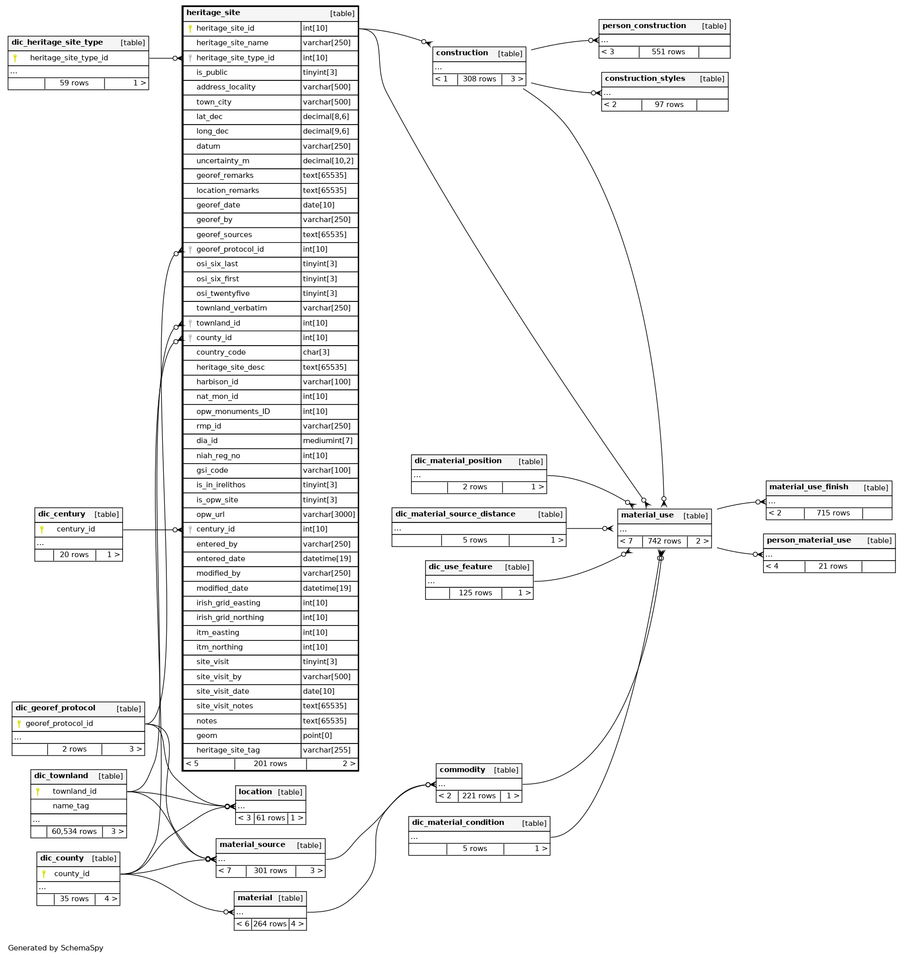
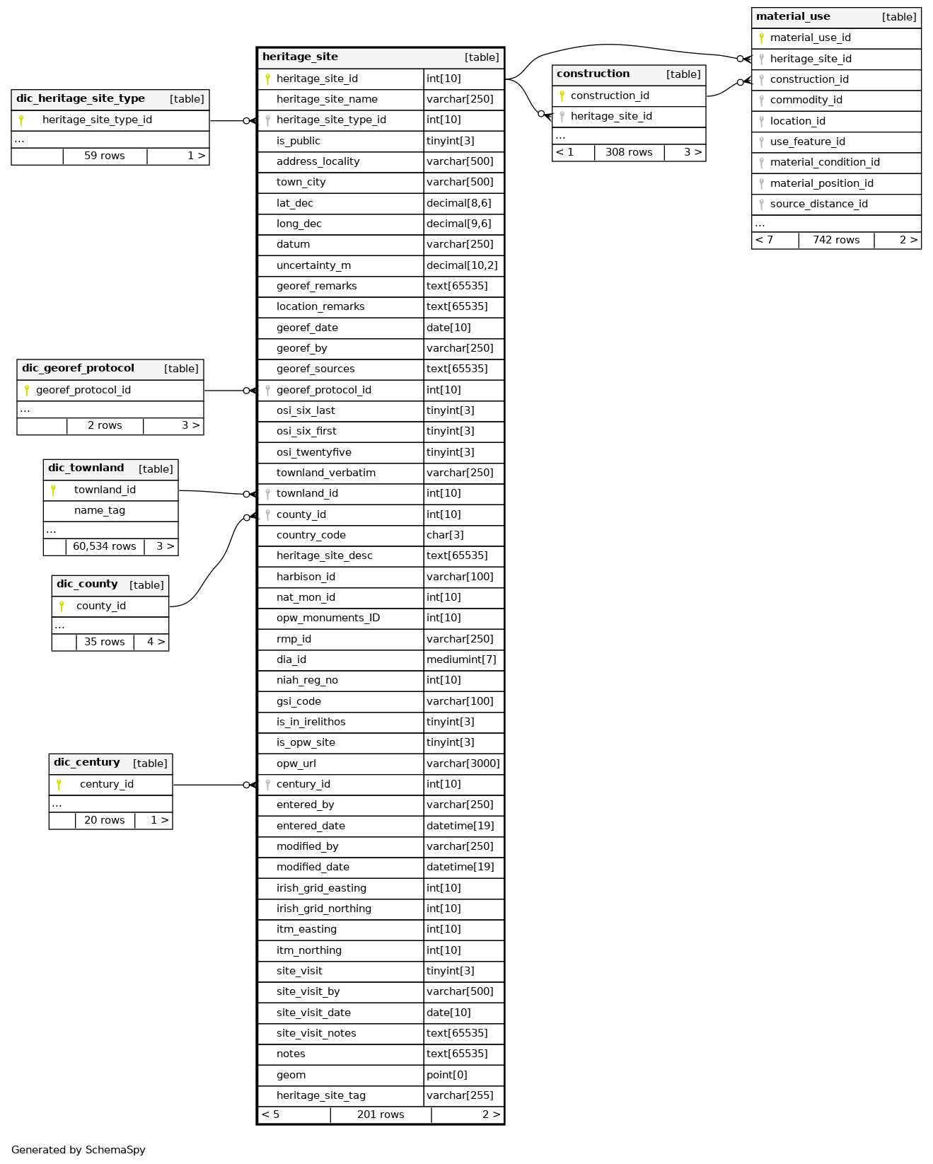
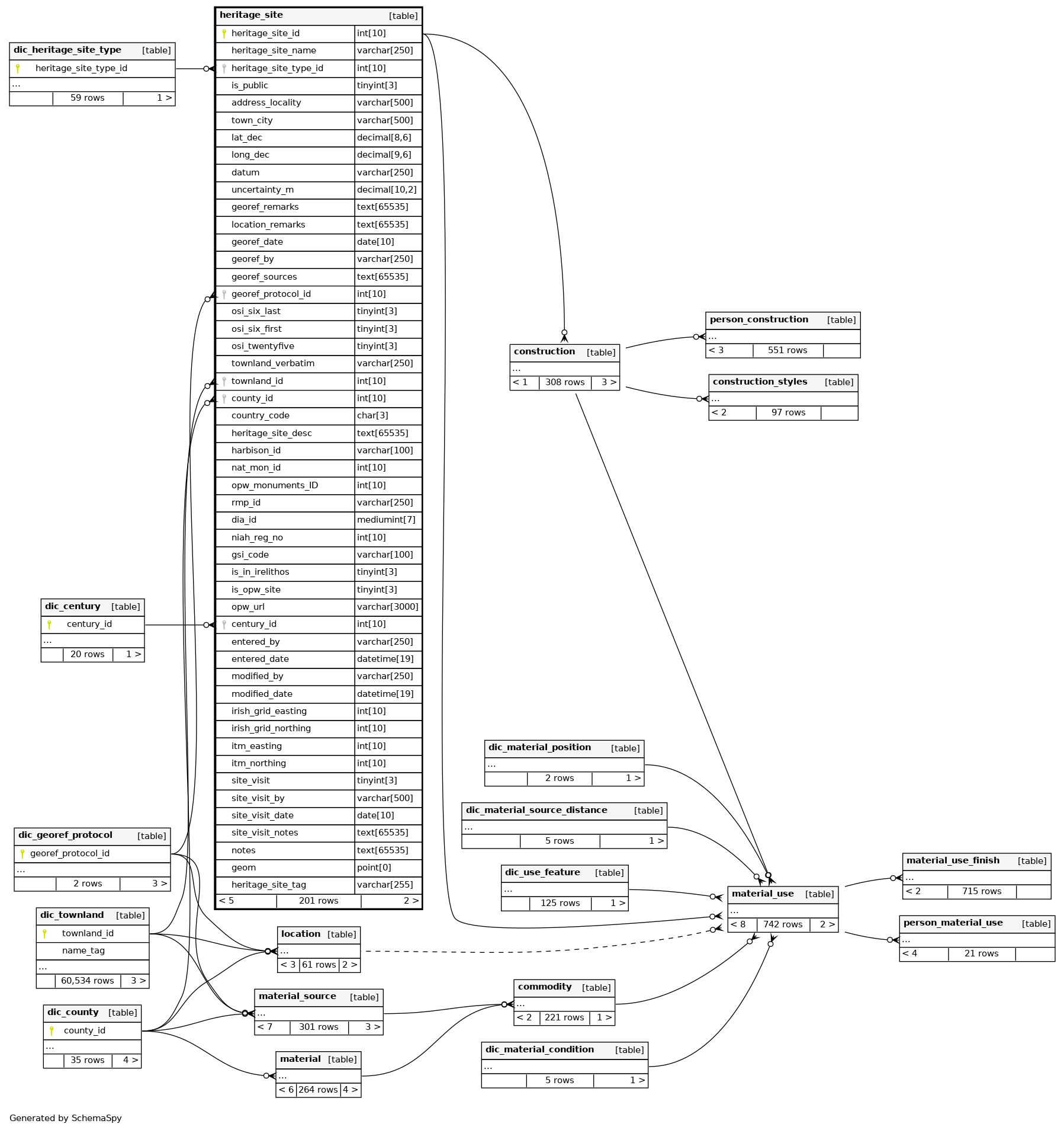
Relationships
Close relationships within degrees of separation