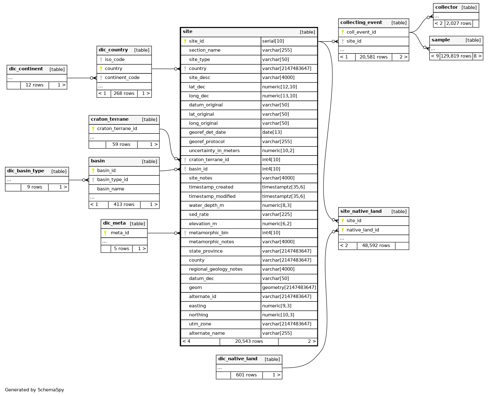
Columns
| Column | Type | Size | Nulls | Auto | Default | Children | Parents | Comments | ||||||
|---|---|---|---|---|---|---|---|---|---|---|---|---|---|---|
| site_id | serial | 10 | √ | nextval('site_site_id_seq'::regclass) |
|
|
PK. Unique identifier for a site. Generated by database |
|||||||
| section_name | varchar | 255 | √ | null |
|
|
Section name, or site name. |
|||||||
| site_type | varchar | 50 | √ | null |
|
|
Site type: outcrop, core, cutting, modern, modern_freshwater, modern_marine |
|||||||
| country | varchar | 2147483647 | √ | null |
|
|
FK. Country name from the dic_country table, a dictionary of higher countries and seas, and their ISO codes. |
|||||||
| site_desc | varchar | 4000 | √ | null |
|
|
Description of the site, e.g. 4 km southeast of the Dazhuliushui mine site. |
|||||||
| lat_dec | numeric | 12,10 | √ | null |
|
|
Latitude in decimal degrees. |
|||||||
| long_dec | numeric | 13,10 | √ | null |
|
|
Longitude in decimal degrees. |
|||||||
| datum_original | varchar | 50 | √ | null |
|
|
Geodetic datum for the original latitude and longitude measurement e.g. NAD27, WGS84. |
|||||||
| lat_original | varchar | 50 | √ | null |
|
|
Latitude as reported in original publication or field notes, or provided by the collector. |
|||||||
| long_original | varchar | 50 | √ | null |
|
|
Latitude as reported in original publication or field notes, or provided by the collector. |
|||||||
| georef_det_date | date | 13 | √ | null |
|
|
Date georeferenced, used if no original lat-long provided. |
|||||||
| georef_protocol | varchar | 255 | √ | null |
|
|
Georeferencing protocol e.g. Georeferencing Quick Reference Guide Version 2012-10-08. |
|||||||
| uncertainty_in_meters | numeric | 10,2 | √ | null |
|
|
Radius of uncertainty in meters - takes into account the locality description, map scale, datum, precision and accuracy of the sources used to determine coordinates - see Quick Reference Guide, Wieczorek et al. 2004. |
|||||||
| craton_terrane_id | int4 | 10 | √ | null |
|
|
FK. ID for the craton or terrane. Links to the craton_terrane table. |
|||||||
| basin_id | int4 | 10 | √ | null |
|
|
FK. ID for the sedimentary basin. Links to the basin table. |
|||||||
| site_notes | varchar | 4000 | √ | null |
|
|
Notes about the site, not part of the description - e.g. source of lat-long, where the site is illustrated. |
|||||||
| timestamp_created | timestamptz | 35,6 | now() |
|
|
|||||||||
| timestamp_modified | timestamptz | 35,6 | √ | now() |
|
|
||||||||
| water_depth_m | numeric | 8,3 | √ | null |
|
|
Water depth in meters, for modern sediment collections. |
|||||||
| sed_rate | varchar | 225 | √ | null |
|
|
Sedimentation rate, for modern sediment collections. Varchar to accomodate very variable modes of reporting, including ranges. |
|||||||
| elevation_m | numeric | 6,2 | √ | null |
|
|
Elevation in meters. |
|||||||
| metamorphic_bin | int4 | 10 | √ | null |
|
|
FK. ID for the low temperature metamorphic bin. Links to the dic_meta table table. |
|||||||
| metamorphic_notes | varchar | 4000 | √ | null |
|
|
Notes about how the metamorphic bin was determined |
|||||||
| state_province | varchar | 2147483647 | √ | null |
|
|
State or province |
|||||||
| county | varchar | 2147483647 | √ | null |
|
|
County or equivalent |
|||||||
| regional_geology_notes | varchar | 4000 | √ | null |
|
|
Notes about the regional geology. Added to accomodate data from USGS databases |
|||||||
| datum_dec | varchar | 50 | √ | null |
|
|
Datum of the decimal latitude and longitude, where known. May differ from datum_original - in some cases, for example, lat-long has been converted to WGS84. |
|||||||
| geom | geometry | 2147483647 | √ | null |
|
|
PostGIS spatial data type - geometry. From decimal latitude and longitude, assuming WGS84 datum. |
|||||||
| alternate_id | varchar | 2147483647 | √ | null |
|
|
Alternate identifier for the site. Added to accommodate IDs from OZCHEM |
|||||||
| easting | numeric | 9,3 | √ | null |
|
|
Easting. First added to accommodate data from OZCHEM. |
|||||||
| northing | numeric | 10,3 | √ | null |
|
|
Northing. First added to accommodate data from OZCHEM |
|||||||
| utm_zone | varchar | 2147483647 | √ | null |
|
|
Universal Transverse Mercator zone |
|||||||
| alternate_name | varchar | 255 | √ | null |
|
|
Alternate name for the site (not commonly used). |
Indexes
| Constraint Name | Type | Sort | Column(s) |
|---|---|---|---|
| site_id | Primary key | Asc | site_id |
| idx_site_geom | Performance | Asc | geom |
| lat_dec_idx | Performance | ||
| long_dec_idx | Performance | ||
| section_name_idx | Performance | ||
| site_metamorphic_bin_idx | Performance | Asc | metamorphic_bin |
| site_site_type_idx | Performance | Asc | site_type |
Relationships
Close relationships within degrees of separation